The Known World - Bridgeman - Art, Culture, History


The Known World
Mapmaking has been an integral part of the human experience, from cave paintings to the present day. The imagining and intepreting of our geographic environment helps us to define and explain the world and our place within it. The Bridgeman archive has many cartography images, from the most important historical records to portraits of notable mapmakers and scholars.
The Journey of an Artist: Anne Truitt
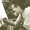
The journals of sculptor Anne Truitt, a major figure in 20th century American art, are being re-released in print and audio versions this month. Bridgeman sat down with Truitt's daughter Alexandra to speak about her mother, the teachers, writer and artist.
Read moreThe Israel Museum
From prehistory to contemporary art and photography, the Israel Museum offers an in depth examination of both Jewish art and Jewish life.
Read more50th Anniversary of the March on Washington
The March on Washington and Martin Luther King's historic 'I Have a Dream' speech delivered on the steps of the Lincoln Memorial, took place 50 years ago on August 28th.
Read more


Ancient Mapmaking
The Turin Papyrus Map from ancient Egypt c. 250 B.C.E., considered to be the oldest topographical map, was thought to be used for mining. It details where gold deposits can be found in the hills, as well as noting differences in soil and rock types.
Where the Egyptian papyrus attempts to render a real accounting of the land, the Babylonian World Map c. 600 B.C.E. is a symbolic representation of the Babylonian worldview. For example, it deliberately omits their Persian and Egyptian neighbors.

The World According to Ptolemy
Perhaps no one had more influence over cartography than Ptolemy (90-168 CE). He believed that the earth could be mapped accurately utlilizing astronomy and mathematics, and reinforced the idea presented by several other Greek scholars, including Aristotle, that the earth was round. His eight-volume atlas, Geographia, was monumental in providing a 'map' for how to render the earth in two dimensions and how to use latitude and longitude to determine location. Ptolemy's tome was the pervasive reference up until the Renaissance period. In fact, Columbus may not have gone on his momentous voyage if it weren't for Ptolemy's striking error in calculating the size of Eurasia!

The Middle Ages
Muslim scholars in the early Middle Ages set out to refine mapmaking traditions, particularly those of Ptolemy. The patronage of Abbasid caliph al-Ma'mun enabled scholars to define the measurement of the mile in comparison to the Greek standard, the stadion. This, in turn, enabled them to calculate the circumference of the earth. During the 9th century Muhammad ibn Musa al-Khwarizimi, a Persian scholar, revised and corrected Ptolemy's calculations in his "Book on the appearance of the Earth." Later maps are now believed to be based on his calculations rather than Ptolemy. Muslims were prolific mapmakers, with many regional schools of thought (example. right).
As Muslim cartography was getting more scientific, the opposite was happening in Europe. The spread of Christianity influenced the way people thought of the world, most maps of this period represented the world one of two ways; a single land mass surrounded by ocean or "the four corners" ideal mentioned in the Bible. Mappa Mundi (or, cloth of the world) is a term used to describe European maps from this period.
The Age of Exploration
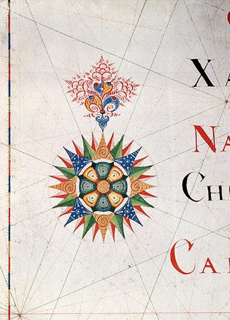
Leading up to and during the Renaissance era, navigational maps took center stage and provided a stark contrast to symbolic maps of the time. As people's knowledge of the world grew through commerce and colonial expansion, the race was on to find new trade routes and raw materials to exploit. The results of surveying coastal territory became known as a portolan chart. The Catalan Atlas c.1375 is an important example of early navigational maps as it provided coastal information such as tides and featured the first compass rose. The compass rose (or wind rose) was a navigational tool used to display the orientation of the cardinal directions, and is still used today. Unlike many other maps, North is shown at the bottom of the map instead of the top.
During the 15th and 16th centuries, the invention of the printing press and advances in mathematics greatly impacted cartography. Important maps during this period are Martin Waldseemuller's map of 1507 showing the entire longitude of the earth and maps by Juan de la Cosa during his travels with Columbus to the New World. The Mercator Projection, several centuries ahead of its time, became the standard for nautical cartography because of the way it laid out the globe in a linear fashion.
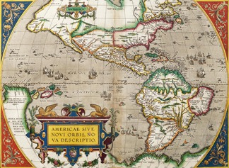
The Golden Age of Cartography
From the mid-16th century through the 17th century, the Dutch dominated the art of commercial cartography. Maps and atlases, like works of art, suddenly became sought after possessions and an extensive trade of Dutch maps began worldwide. In 1570 an Antwerp cartographer, Abraham Ortelius, published an extensive atlas called Theatrum Orbis Terrarum (Theater of the World), which is considered to be the first modern atlas. This work was immensely popular. It was published in seven languages and had the distinction of being the most expensive book of its time. There are also many examples of cartography from the Dutch colony of New Amsterdam, now New York City, from this same time period. One iconic work is the Costello Plan from 1660, below.
In addition to being wonderful examples of human ingenuity, maps are also beautiful works of art. One of our favorite works (map or otherwise) is a terrestrial globe created by Vincenzo Maria Coronelli in 1688 for Louis XIV. Click here for details from Coronelli's masterpiece.

Navigate
- Terms & Conditions (UK)
- Terms & Conditions (US)
- Terms & Conditions (FR)
- Terms & Conditions (DE)
- Copyright
- Privacy Policy
Join our mailing list
Receive Bridgeman news, events and special offers direct to your inbox
Name:
Email:

Contact Bridgeman
Bridgeman Art Library International
274 Madison Avenue, Suite 1604
New York, NY 10016
United States
+1 212 828 1238
Did you know?
We have a team of dedicated experts who can help you with image research and provide tailored price agreements for your organization. Contact us to discuss your requirements
We use cookies to give you the best experience of our website. Some may have been set already.
If you continue without changing your settings, we’ll assume that you are happy to receive all cookies on our website. Read about how we use cookies.